
Mexico City Is Sinking Fast — NASA Now Watching It Live from Space
Mexico City/ Washington: More than 20 million residents of Mexico City are living atop ground that has been gradually sinking for over a century—a process now being monitored with unprecedented precision from space.
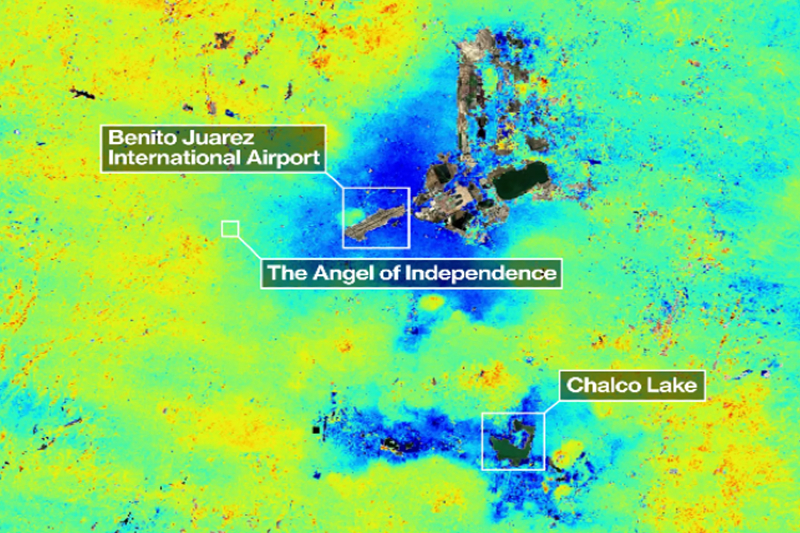
In a major technological leap, NASA has released new observations from the NISAR satellite, showing that parts of the sprawling metropolis are subsiding by more than half an inch each month. Scientists say these seemingly small shifts accumulate over time, leading to severe structural damage, including cracked roads, tilting buildings, and ruptured water pipelines.
Real-Time Monitoring Changes the Game
Unlike earlier systems that provided only occasional or yearly data, the NISAR satellite can track ground movement every 12 days. Developed jointly by NASA and the Indian Space Research Organisation, the satellite uses dual radar frequencies to produce highly detailed, near real-time measurements of land deformation.
Researchers say this allows them to build continuous “time series” maps of how different parts of the city are shifting—something that was not possible before.
Uneven Sinking Worsens Urban Damage
Experts have long known that Mexico City is sinking, but the new data highlights how uneven the process is. Some neighborhoods are subsiding faster than others, creating dangerous fractures in the ground.
Areas such as Iztapalapa have been particularly hard hit. According to long-time researchers, buildings constructed on soft, former lakebed soils are especially vulnerable, while those anchored in volcanic rock remain relatively stable.
A Problem Rooted in History
The city’s sinking is closely tied to its origins. Built on the drained bed of an ancient lake, the land beneath Mexico City has been compressing for decades due to excessive groundwater extraction.
As water is pumped from underground aquifers, the soil compacts—much like wet clay drying and hardening—causing the surface above to sink permanently.
Historical records show that the problem has worsened over time. By the late 19th century, the city was already sinking by a few inches annually. That rate surged dramatically by the mid-20th century, and in some areas today, total land loss has reached tens of feet.
A Global Warning Sign
Scientists warn that Mexico City is not an isolated case. Similar patterns of land subsidence are being observed in coastal and densely populated regions worldwide, where sinking land combined with rising sea levels poses a growing threat.
With the launch of NISAR in July 2025, experts now have a powerful tool to monitor these risks globally. The satellite is expected to play a crucial role in identifying vulnerable regions and helping governments respond before damage becomes irreversible.
As urban populations continue to grow and climate pressures intensify, the ability to track the Earth’s subtle movements in real time could prove vital in protecting millions of lives and critical infrastructure.